Archives

All posts by Ravenswood Historical Society Webmaster

Download the PDF file .

This is a self-guided tour of the Ravenswood neighborhood. The tour starts at the Metra Stop for Ravenswood and proceeds south along Commercial Avenue (now Hermitage). The people who lived along the route, the architecture and the history of the area will be discussed.
The tour is under two miles and is flat.
Do not park on Ravenswood north of Lawrence as the parking there is private. There is public parking on Ravenswood south of Lawrence both east and west of the Metra railroad. There is also metered parking on Lawrence.
Most side streets in this area are not zoned, meaning you can park on most side streets.
There are numerous restaurants available for relief and refreshment. They are located on Ravenswood, Lawrence, Irving Park and Montrose. A small play lot is available near the end of the tour. In summer the play lot will have a working water fountain.
Near the end of the tour is a large city park with rest rooms and working water fountains.
The tour will use geo-location from your cellular device in the future. It is currently available off-line.
For your convenience, the tour is published below.

MAP OF THE TOUR (Letters do not correspond to any address)

tourmap

4800 North Ravenswood Avenue

Early Human Settlement

The State of Illinois is an outgrowth of the history of many peoples. Many of their influences have vanished, sealed beneath the foundation of homes and the construction of roads. Here, in Ravenswood, Native Americans lived for thousands of years prior to the first European explorers.

Pause a moment here, on the train platform and have a look around. In your mind’s eye, can you remove the buildings and roads to imagine what this place was like 500 years ago?

This area lies about a mile from Lake Michigan and about a mile from the Chicago River. Prior to European settlement the area was a mix of marsh and low sandy ridges, one of which formed the Green Bay Trail.

Today we call the Green Bay Trail by a different name: Clark Street.

Mound people, called Mississippians, probably established a settlement about six miles from here in Chicago near Wolf Point. The collapse of the Mississippian culture coincided with the ravages due to the introduction of Euro-Asian diseases, the beginning of the Little Ice Age and the introduction of horses to North America.

We are not aware of any Mississippian culture locations in the Ravenswood area.1 2

Sometime around the collapse of the Mississipian culture in 1500 C.E. the Neshnabek tribe migrated from what is now Western Ontario to an area on the eastern shore of Lake Michigan. In 1634 Jean Nicolet, a French explorer, met members of the tribe at Red Bank, Door County, Wisconsin. It is during this encounter that the Neshnabek tribe first became known as the Pouutouatami.3

The rage of the Iroquois forced Eastern tribes to flee into the the Midwest. Attacks by the Iroquois in the Ontario Peninsula against the Potawatomi, Sac, Fox, Kickapoo and the Miami temporarily ended European exploration of the Midwest. As a result of the Iroquois attacks, the Potawatomi relocated across Lake Michigan to Green Bay and Door County in Wisconsin.4 By 1667 the French and Iroquois had agreed on peace terms allowing French coureurs de boid to search further into the Midwest for fur.5
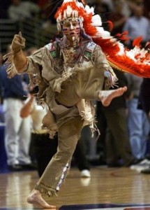
Chief Illiniwek, a modern interpretation of the tribe that once lived in the Chicago area.

Chief  Illiniwek, a modern interpretation of the tribe that once lived in the Chicago area, was once the mascot of the University of Illinois. The school was criticized for what many people, including Native Americans, considered a racist depiction of the Illiniwek tribe.

The native people around the tip of Lake Michigan called themselves the Illiniwek. Their tribe gave their name to the state through the French: Illinois.6

Their tribe spoke a language shared by many other tribes, Algonkian. Those tribes included the Cahokia, the Kaskaskia, the Michigamea, Moingwena, Peoria, Miami and Tamaroa.

Despite their shared language, the Miami were considered a separate tribe from the Algonquin confederacy.

French influence in the area increased with a key moment being the first European use of the Chicago portage by Rene’ Robert Cavelier de LaSalle in 1670.7 In 1671, in a ceremony held at Sault Saint Marie, the French laid claim to the lands of the Illinois.8

The population of the Illiniwek were estimated to be about 6,500 by Father Louis Hennepin, OFM, a French missionary about the year 1680. de La Salle, in 1684, states about 1,200 Illinois warriors gathered at Fort St. Louis in that year.

The Illiniwek and the other tribes encountered by the French, were not settled people. Some of the older members of the tribe, along with slaves, would plant fields of maize, gourds and pumpkins. These fields would be left for growing as the tribe engaged in hunting elsewhere.

Winter quarters may have consisted of long arbors covered with mats of reeds.

The Illinois Confederation of tribes could not resist the Iroquois invasion of the Midwest. Many of the tribes crossed the Mississippi River to settle in Kansas, Missouri and other western states.

In the years that followed the area around the mouth of the Chicago River changed hands several times. The Miami, the Potawatomi, a French garrison, the Potawatomi and the Chippewa, the French again and finally the British, who took control of the area in 1763.

The Potawatomi remained a force in the area, allying against the US and with the British, even after the Treaty of Paris gave the US sovereignty of the area. In 1812 a Potawatomi band ambushed the garrison of Fort Dearborn as it attempted to march to Fort Wayne.

The total defeat of the US forces temporarily ended US administration of the Chicago region. US forces militarily defeated the Potawatomi, being led by Tecumseh, at Moraviantown, Ontario in 1813.9

The US rebuilt the destroyed Fort Dearborn in 1816. You can see its outline today at the corner of East Wacker Drive and North Michigan Ave.

The US defeat at Fort Dearborn had unfortunate long-run consequences for Native tribes. Remembering the ‘massacre’, European settlers demanded the removal of all native tribes from the new state of Illinois.

In 1832 the last major Native American effort in Illinois ended in disaster as the local militia, regular US Army units and Sioux nearly exterminated Chief Black Hawks followers of Sac and Fox at Bad Axe in Wisconsin.10

A treaty signed in Chicago in 1835 (the Chicago Treaty of 1833) caused the evacuation of the Potawatomi from Illinois. According to Ron Grossman, writing for the Chicago Tribune, 500 warriors gathered in Chicago to conclude the treaty, dancing in full dress and brandishing tomahawks.

It was the last recorded war dance in the Chicago area.11

Continue Reading

4611-4613 North Hermitage

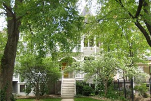
These houses were built in 1990 by architect Patrick Fitzgerald. He designed the houses with sensitivity to the surrounding neighborhood, and to the other structures immediately around the two new buildings.

4611 N Hermitage. Credit: Cook County Assessor

4611 N Hermitage. Credit: Cook County Assessor

WALKING DIRECTIONS TO NEXT LOCATION

Continue the tour to 4604 North Hermitage Avenue.

  1. The next building is across the street, about 33′ from you.
  2. Click the ‘Continue the Tour’ button below when you’ve reached your destination.

MAP OF DIRECTIONS TO NEXT LOCATION


View Larger Map

Wilson & Commercial Avenues

Before it was called Hermitage, this street was named Commercial Avenue. With the Abbott Mansion on your left shoulder, gaze first across Wilson Avenue.
New buildings can be seen for some distance down Hermitage. The Ravenswood YMCA once stood here. It was built in 1905. By the late 1970’s the building was in need of financially significant work to bring it up to the standards of the day.
As a result the YMCA was demolished. Developers later purchased the land. We’ll get to that in a moment.
Across the street is the All Saints Episcopal Church. Built in 1883, the church is believed to be the oldest frame church remaining in the city. We’ll get to that in a moment too.
Continue to turn to the right. A restaurant/ bar called O’Shaughnessy’s currently occupies the Pickard Building, located at 4557 N Ravenswood.

Pickard China

Pickard China used the building to house artists on the second floor. They painted imported white china.

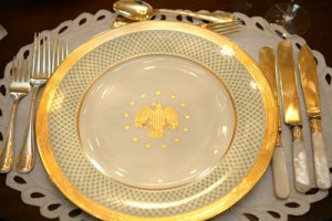
President George W Bush formal china set.

President George W Bush formal china set. Credit: White House Museum

First established in Edgerton, Wisconsin, the company was moved to Chicago by its founder Wilder Pickard. Artists from Europe and the Art Institute of Chicago decorated the one of a kind ceramic pieces, now highly prized by collectors.
In the 1920’s the company developed a line of fine china dinnerware. The company moved to Antioch, Illinois in 1930.
The line of china used by the US Department of State for dinners in our embassies and missions is manufactured by Pickard. Perhaps you’ve been invited to dinner at an embassy and seen this local company’s product appear below your plate?

Albert “The Sausage King” Luetgert

Albert Luetgart was among the many entrepreneurs building an empire on the backs of hogs. The Foreman Brothers Bank, which was once located in the Pickard Building, was embarrassed to discover, in 1898, that it held Albert’s mortgage.

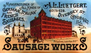
The Luetgart Sausage Works.

The Luetgart Sausage Works.

Albert had established a packing house and stockyard on the city’s North Side, in the 1700 block of  West Diversey Avenue, in 1879. It had become very successful over the years, from an initial investment of four thousand dollars to a point where the A.L. Luetgert Sausage & Packing Co. was considered the ‘sausage king’ in the 1890’s.
On May 1, 1897 Mrs. Luetgert, Louisa, disappeared.
Albert told his children their mother was visiting her sister. After a few days, Diedrich Bichnese, Louisa’s brother, reporter her missing to the police.
Luetgert now said Louisa had run away with another man.
A police investigation demonstrated a history of domestic violence and financial difficulties. Albert, it turned out, was seeing a wealthy widow. He planned to marry her once he got rid of Louisa.
Further police inquiries discovered that Louisa was seen on the evening of May 1 entering the factory with Albert at about 10:30 p.m.. The police discovered that Albert had sent the night watchman home early that night, though the man confirmed he had seen Louisa enter the plant. And the police discovered Albert had purchased arsenic and potash the day before. Those chemicals were not common in the manufacture of food products.
A search of the factory found suspicious sausage and human residue in an oven. Two of Louisa’s rings and human remains were found. Albert was arrested and tried for the murder.
Albert claimed there were numerous reports of Louisa being seen around the US, casting enough doubt that the jury was unable to reach a verdict in 1897.
A second trial was held in 1898. This time the prosecution used George Amos Dorsey, an anthropologist at the Field Museum, to prove to the jury that the bones were human. Protesting his innocence, Albert was sent to prison. He died there in July 1899.
The trial was a media circus, widely reported and leading to media excesses. It was among the first cases that depended on a forensic expert to resolve the crime.

Zephyr Cafe & Ice Cream

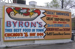
Byron Kouris was among the many Greek- Americans who entered the restaurant business. In the 1960’s he started a chain called the Lunch Pail. He started Byron’s Hot Dogs with locations in Ravenswood (1701 W Lawrence Avenue), Wrigleyville (1017 W Irving Park Road), the Near West Side (680 N Halsted Street) and Lincoln Park (850 W North Avenue).

A restaurant called the Zephyr once operated in the Pickard Building. It was owned by Byron Kouris, better known as the owner of Byron's Hot Dogs.

A restaurant called the Zephyr once operated in the Pickard Building. It was owned by Byron Kouris, better known as the owner of Byron’s Hot Dogs. Credit: Shy Full of Bacon

In 1976 he started Zephyr in the Pickard Building. For 30 years, ending in 2006, the Zephyr was known for its huge ice cream dishes.
Byron’s was inducted into the Vienna Beef Hot Dog Hall of Fame. In 2010 a replica Byrons served hot dogs on the lawn of the White House for the 2010 Congressional Picnic.
Byron closed the Zephyr, to the sorrow of many neighborhood children with eyes larger than their stomachs. He died in March 2006 at age 76.
Here’s a question for you: why is this group of commercial buildings on Wilson Avenue HERE? In most cases, these intersections have small commercial strips facing Ravenswood Avenue. The Wilson Avenue strip extends for a block west past Ravenswood.
The answer lies about an eighth of a mile west where you may see a Chicago Transit Authority train running on the Brown Line elevated platform. Until the early 1950’s the Brown Line, then known as the Ravenswood Line, had a stop here at Wilson Avenue. In addition, the Chicago & Northwestern Railroad had a depot here serving Ravenswood.
The Brown Line was built into the neighborhood with the Western Avenue station opening in May 1907. A real estate boom followed. The ‘L’ allowed inexpensive and fast service from the area to the city center.

WALKING DIRECTIONS TO NEXT LOCATION

Continue the tour to All Saints Episcopal Church, 4550 North Hermitage Avenue.

  1. Cross the street to All Saints Episcopal Church
  2. Click the ‘Continue the Tour’ button below when you’ve reached your destination.

MAP OF DIRECTIONS TO NEXT LOCATION


View Larger Map

4228 North Hermitage Avenue

4228Hermitage

4228 N Hermitage Ave., the home of Chicago Mayor Rahm Emanuel. Credit: Cook County Assessor

RahmHome2

A decision regarding the residency of Rahm hung on his assertion that he had stored personal possessions in the home, showing his intent to return. The residents, not aware of the storage, denied there were any such storage. Credit: NBC Chicago

This is the home of Chicago Mayor Rahm Emanuel and his wife Amy Rule. They purchased the home in 1998. At the time Emanuel was an investment banker and a member of the board of directors of Freddie Mac. In 2002 Emanuel became the Congressman for the 5th Illinois Congressional District, succeeding former Governor Rod Blagojevich in that post.
In 2010 the building became an object of intense media interest. Long-time Mayor Richard M Daley announced he would not run for reelection in September 2010. Emanuel, then the Chief of Staff for US President Barack Obama, announced he would run for the office.
Burt Odelson, a well-known election law attorney, filed challenges to Emanuel’s candidacy on behalf of Walter P Maksym Jr. and Thomas L McMahon. Soon a crowded field of objectors had joined the challenge.
At issue was whether Emanuel, by renting the home to take up his position at the White House, had forfeited his city residency, a requirement to run for mayor.
The tenant, Rob Halpin, not only testified against Emanuel, but filed to run for the office also.
Emanuel stated that he always intended to return to the home. He further alleged that he had stored Amy Rules’s wedding dress, his children’s first clothes, books, diplomas and other items in the home. As the hearing progressed, it became clear that the decision could hang on the storage Emanuel alleged was happening.
Lori Halpin, Rob Halpin’s wife, testified before an elections hearing that “there have never been boxes in the house that weren’t mine.”
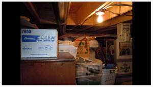
However, attorneys for Emanuel were able to produce photographs of an area of the house that Lori Halpin had not been able to access.
The election hearing decided in favor of Emanuel, a decision that was upheld by the Illinois Supreme Court.

SOURCES

Residency Biggest Challenge for Rahm Emanuel in Chicago Mayoral Race
Rahm Emanuel Testifies in Chicago Mayor Residency Challenge
Photos Confirm Rahm’s Boxes

WALKING DIRECTIONS TO NEXT LOCATION

Continue the tour to 4224 North Hermitage Avenue.

  1. The next building is about 33’south from you.
  2. Click the ‘Continue the Tour’ button below when you’ve reached your destination.

4147 North Ravenswood Avenue

This building contained the political offices of former Illinois Governor Rod Blagojevich, offices the federal government say he used for wire fraud, attempted extortion and a conspiracy to solicit bribes. As part of its investigation into Blagojevich the federal government taped the offices located here.
The first serious allegation against Blagojevich was related to the federal case against Tony Rezko when it was revealed that Blagojevich was Public Official A of the Rezko indictment.

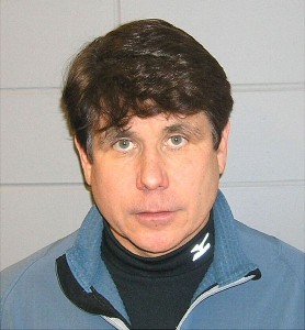
The mug shot of former Illinois Governor Rod Blagojevich. Credit: Wikipedia

The mug shot of former Illinois Governor Rod Blagojevich. Credit: Wikipedia

On December 9, 2008 US Attorney Patrick Fitzgerald had Blagojevich and his Chief of Staff John Harris arrested at their homes. Fitzgerald said in a press conference the arrests were meant to prevent Blagojevich from gaining personal benefit from the imminent appointment of a replacement to the US Senate for Barack Obama.
Blagojevich was the seventh Illinois governor arrested or indicted and the fourth since 1971.
Turning the state impeachment into a media circus, Blagojevich made appearances on television shows such as Good Morning America and The View instead of attending the proceedings in Springfield.

SOURCES

All documents from the 2011 federal trial
US v. Blagojevich & Harris– the criminal complaint

WALKING DIRECTIONS TO NEXT LOCATION

Continue the tour to 4232 North Paulina St.

  1. Turn back north towards Berteau. When you reach the corner, in about 138′, turn right.
  2. Cross the alley and back across Hermitage, continue past the former Mary Courtney school building to Paulina St. , about 0.2 mile, to Paulina St., the first street after Hermitage. Turn left.
  3. Do not cross Paulina. Go north on Paulina about 367′ to your destination.
  4. Click the ‘Continue the Tour’ button below when you’ve reached your destination.

MAP OF DIRECTIONS TO NEXT LOCATION


View Larger Map

Welcome to the new website for the Ravenswood Lake View Historical Association.  We are dedicated to preserving and disseminating the history of Chicago, Illinois’s north side, particularly the neighborhoods of Ravenswood and Lake View.

In conjunction with the Chicago Public Library, the Association maintains an extensive collection of books, photos, newspaper articles, and audio and video recordings at the Conrad Suzler Regional Library, 4455 North Lincoln Avenue, Chicago, Illinois.

The Association frequently presents programs with authors and historians touching on matters of historical importance to the Ravenswood and Lake View neighborhoods.  Check the events page on this site for upcoming events.

The official boundaries of Ravenswood-Lake View Historical Association are North Avenue, the Chicago River, Devon Avenue, and Lake Michigan.  While the official area takes in many neighborhoods, Ravenswood and Lakeview are the primary focus of the Association.

The Association is an Illinois not-for-profit corporation certified by the Internal Revenue Service as a 501(c)(3) tax-exempt organization.

Sulzer Road

You’ve reached Montrose Ave. Did you know that Montrose Avenue is named for James G Montrose, the Marquis of Hamilton, a Scottish noble and Royalist leader in the reign of Charles I?

We have a better candidate for the name of this street: Sulzer Street.

Conrad Sulzer was a Swiss immigrant to the US. He was among the first Europeans to settle in this area. A truck farmer, his family remained active in the area well into the 20th Century.

Grace Sulzer established the Sulzer Family Foundation to ensure that civic, social and educational organizations continue to thrive and enrich the community founded by her grandfather.

And we think this should seal the deal. The street you are at the corner of? It was renamed to Montrose from Sulzer.

Ravenswood School (3)

The outside of Ravenswood School has remained relatively unchanged since a north and south wing were added to the building about 1912.

So much has changed since Conrad Sulzer pioneered this land. We’d like you to join us with a remembrance from an unknown early settler after the break.

Continue Reading